1. Discuss the role of remote sensing to monitor Land-use changes.
→ The change in land use from rural to urban is monitored to estimate populations, predict and plan the direction of urban sprawl for dep developers, and monitor an adjacent environmentally sensitive area of hazards.
→ In developing countries that often don't have reliable Table population databases, interpretation of high-resolution imageries can be used to estimate housing density.
→ Also used in transportation studies & can be used to identify vehicle types, and traffic flow parking problems ete.
• Satellite products used for land-use changes:
• Landsat satellites : If have the optimal ground resolution & spectral band to efficiently track land use e to document land change due to climate change, urbanization, drought, wildlife, and biomass changes.
→ Many sensors have been on based the land sat supplies of satellites including RBV, MSS, and TM.
→ MSS & TM can collect data over a swath width of 185 km, with the far scene being defined, as 185 km x 185 km.
• SPOT-4 & 5 :
→ It has several notable features of significant value for earth resource remote sensing including an independent sensor called simply I for small-scale vegetation.
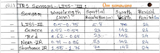
→ The spectral resolution is 0.43 -0.89 from bands 1-3.
→ Swarth is 2266 km 150.5°.
→ The Revisit Period Is 1 Day.
• MODIS - MODI SC 2:
→ It is used globally from displaying the land cover of land cover changes.
→ Band - has spectral resolution 0.620-0.670 & spatial resolution 250 m x 250 m.
2. Discuss the crop Health Monitoring remotely sensed images.
→ Assessment of the health of the crop, as well as early detection of coop infestations, is vital for ensuring good agricultural productivity stress associated with.
→ for Ex, Moisture deficiencies, insects & fungi must be detected early enough to provide an operation for farmers to mitigate.
→ Remote sensing platforms & series of satellites used for crop monitoring are IKONOS, SPOT, ERRA, IRS Radagset & CBERS.
→ Remote sensing indices like NOVI, LSWI, JVDE, SAVI, WDI, etc are helpful to derive crop development f soil humidity state.
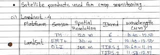
• Satellite products used for crop monitoring.
Applications :
→ Discriminating vegetation and crop.
→ Precision farming land management.
→ Monitoring crop fi forest harvests.
→ Crop water stress.
→ Crop water demand.
• MODIS :
→ It captures records in 36 spectral bands very in wavelength starting from 0.4 × 10⁻⁶ m to 14.4 × 10⁻⁶m.
Application :
→ Crop Phenology meta tiles.
→ Crop water usage.
→ Crop stress.
• Sentinel-2 :
→ It can identify early modification in plant healthiness to differentiate between diverse crops and varieties and distribute appropriate data on diverse biophysical factors.
3. Discuss the application of remote sensing Hydrological Science :
• Wetlands mapping & monitoring:
→ LANDSAT TH is used for mapping wetland changes TM data are sensed in seven special bands simultaneously. Band 6 Sensor TIR.
• Water Quality Monitoring:
→ LANDSAT 7 & Candsats are onboard satellites f used for water quality monitoring.
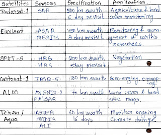
→ Tera & Aqua satellites have Genson ASTER. CERES, MISR, MODIS, MOPIT, AMSV, and AIRS are used for water quality monitoring.
→ MODIS is designed for land, atmosphere, ocean, and cryosphere observations.
• Measuring snow Thickness:
→ ICESAT-2 and CanyoSAT-2 are using different Methods to measure ice thickness.
→ one measure of the top of the snow layer f other is the boundary B/W bottom of the snow layer.
• Rever/delta Change Defection :
→ A set of satellite images from mss. TM & SPOT Sensors were utilized to estimate the Rives/delta changes.
• Snow Mapping :
→ Nimbus -7% SAMR, AQUA I AMSR-E & LANDSAT-TM are used for snow mapping creation.
→ other applied are flood mapping f monitoring - glacier dynamic monitoring, mapping, irrigation can leakage detection f isgigatión scheduling.
4. Discuss the application of remote sensing in Ocean & coastal monitoring.
→ The oceans not only provide valuable food & biophysical sources, but they also serve as transportation routes & crucially important in weather system formation.
• Nimbus - 7 satellite:
→ It was launched in 1978 and carried the first sensor the coastal zone color scanner specially intended for monitoring earth's ocean water bodies.
→ The primary objective is to observe ocean color f temperature, particularly in coastal zones. with sufficient Spatial spectral resolution to detect pollutants in the upper level of the ocean & determine the nature of materials suspended in the water column.
• SEA WIFS:
→ It is monitoring various ocean phenomena 9 including ocean primary production & phytoplankton processes, ocean influences on climate process & monitoring of cycles of c,s & N.
→ Two orbital combinations of spatial resolution mode of 1.1 km over a swath of 2800 km; resolution mode 4.5 over a swath of 1500 km.
• MOS Visible, IR instruments :
→ They are useful for land application in addition, to the observation of marine environments.
→ The mo's system orbit at an attrib altitude of around 900 km and has a revisit period of 17 days.
5. Highlight the remote sensing application in environmental Impact Assessment.
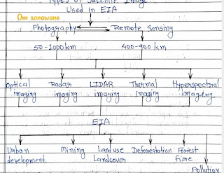
→ EIA is an interdisciplinary decision-making tool for alternative routes for, development, process technology & project sites.
→ Remote sensing help in data collection in various fields,
→ Such as agricultural crop coverage of yield estimation, drought warming & assessment and use of land cover, mapping for agro climate planning, wasteland management, urban development, water resource management, marine resource survey, mutual disaster management, the impact of mining activities, etc Space-based art artificial orbiting satellite like IRS. IB & Ib, LandSAT, NOAA Spot. etc. are useful in collecting information on changes in the earth's environment through remote sensing.
6. Discuss the remote sensing application in hydrology.
→ In hydrology, remote sensing is used for disaster management, disaster presentation, disaster pre parades & rapid & adequate disaster relief.
• Earthquake :
→ It can occur in cycles of decades or centuries rem Hone sensing tech added up to information available through Technology for this purpose land use and geological maps can give vital pointers Town wads potential earthquake zone.
→ NOAA SPOT, LANDSAT & IKONOS all of them collect required data.
• Volcanic Eruption:
→ Remote sensing technology can play an important role [ by providing vital information with only limited fieldwork, which saves effort & money.
→ TIR can capture volcanic heat provided spatial Resolution is high enough.
→ Also, PAN stereo pair imagery due to its capability of moderate resolution would serve the purpose of LANDSAT SPOT-4 f IRS-1D is valuable in volcanic activity detection.
• Tsunamis:
→ Satellite or aerial photography, especially when combined with a good GIS database of an area Lean provide actual information for emergency managers, including damage to the structure, transportation & communications links.
• Hurricanes:
→ Its determination is done by NOAA satellite.
→ At present best sensor is AVHRR with its 2940 km swath. twice a day coverage & appropriate Resolution METEOSAT-2 observed the development of a distinctive cyclone in India ocean B/W 5-9 June 1998.
• Landslides :
→ The large lock landslides can be detected on Landsat mss & TM.
→ Imagery SPOT PAN imagery could be preferred with its atom resolution, various satellites Like ERS, and RADARSATE LANDSAT studies the Landslide occurrence.
→Typically features that signify the occurrence of it, include chaotic blocks of bedrock, crescentic scraps, or scars, whose horns point on the normal looking shape.


.jpg)

0 Comments